A New Zealand Federation of Freshwater Anglers Project

NZFFA Nitrate Testing
The massive increase in the amount of irrigated farmland across Canterbury in recent decades has resulted in a comparable reduction in the region’s water quantity and quality from over allocation and nitrate pollution
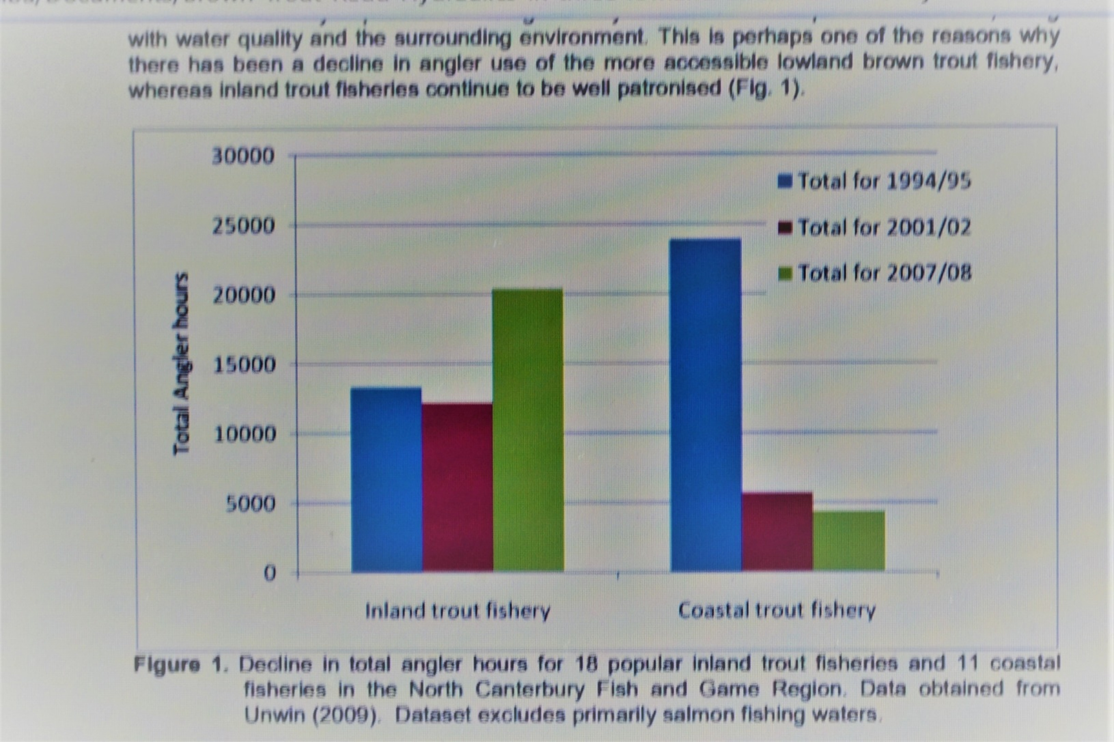
The region’s recreational fisheries at large braided river mouths and in smaller lowland streams and rivers have seen trout numbers decline to near extinction
Initial researching of Ecan’s limited database and NZFFA’s initial nitrate testing suggested toxic levels of nitrate in groundwater was the prime suspect for lowland streams
The loss of native and recreational fish from Canterbury’s hapua appears related to lower residual flows and the loss of the variable flows that define braided rivers due to excessive water abstraction for irrigation.
Ecan Maps monitoring nitrate levels in test wells show nitrate levels have risen markedly over the last decade


The NZFFA initially conducted testing of surface and groundwater in the Ashburton and Selwyn Districts. We found high levels of nitrate in groundwater NE of Ashburton, near Tinwald & Winslow, and in Hinds Township.
The Hinds River tested > 7.0 mg/L NO3-N in its lower reaches. A couple of permanent drains along the Lowcliffe coast exceeded the Maximum Allowable Value for drinking water (11.3 mg/L)
To reduce travel costs and because the Selwyn District had a lower nitrate baseline prior to the Central Plains Water irrigation enhancement scheme it was decided to focus on the surface waters of the lower Selwyn area.
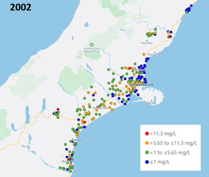
Greenpeace and NZFFA spent a day testing private wells on 31 May 2021 as part of a Greenpeace initiative to raise the awareness of rural residents to the risk of nitrate polluted drinking water

Orange dots > 5.5 mg/L NO3-N
Red dots > 11.3 mg/L (exceeding New Zealand’s maximum allowable value for drinking water)
Rural residents who drink from private wells are left to manage increasing concerns about the health risks from drinking nitrate polluted water themselves.
The Greenpeace data suggests nitrate pollution is a much bigger problem than limited Ecan monitoring has revealed]

With the assistance of Pub Charities NZ, and a generous discount from the instrument supplier, the NZFFA was fortunate in obtaining an optical sensor of our own to conduct nitrate testing
Nitrate polluted groundwater is not a legacy issue. It is an emerging crisis due to the (in)actions of this generation
A legacy Issue?
Ecan’s director of science repeatedly attempts to reassure us by stating; Nitrate pollution of Canterbury’s aquifers is a legacy issue of past farming practices, it is “in the post”, it will get worse before it gets better.
There is some truth in the legacy issue argument evidenced by a 1986 CRC report from the Ministry of Works in Christchurch warning that rural residents between Ashburton and Rakaia would need to source alternative drinking water due to increasing nitrate in groundwater
Tim Davie ignores the “legacy issue” being created from increasing the number of cows in Canterbury from around 100,000 to 1.3 million a decade or more after this MOW report was written.
Why the test the Selwyn Water Zone?
NZFFA decided to test surface water in the lower Selwyn District due to the recent massive Central Plains Water irrigation enhancement scheme as we have no confidence that Ecan’s Land and Water Regional plan will manage this problem
The LWRP appears flawed due to its over reliance on models in lieu of adequate data and its vulnerability from the politics of self-interest.
The loss of Central Canterbury’s lowland fisheries
The consenting of the Central Plains Water (CPW) irrigation enhancement scheme has cost Canterbury anglers dearly
CPW has failed to meet its promise that the scheme would mitigate pre-existing over allocation of ground and surface water in the region
CPW enabled large scale intensive irrigated dairy farming to be developed on 45,000 ha of porous soils especially vulnerable to nitrate leaching
Stage 1 (20,000 ha) operational September 2015, Stage II (20,000 ha) operational October 2018, Sheffield (4,300 ha) October 2017
Environment Canterbury (the Canterbury Regional Council) knowingly chose GDP over pollution
Deposed Ecan councillor Eugene Sage (2007-2010) in a submission tabled at the Ecan managed Hearing to amend the National Water Conservation (Rakaia River) Order 1988 to enable the Lake Coleridge Project (LCP), February 2012, stated that;
“It would be reckless and irresponsible to proceed with CPW before the means and the regulations to manage nitrate leaching from the out of river use were in place.”
Chair of the independent commissioners Hon. Peter Salmon determined that consents to use the Rakaia River water were outside the scope of the LCP Hearing and would be the subject of future hearings
Diffuse nitrate pollution
Diffuse nitrate pollution occurs when synthetic or animal sourced nitrate leaches beyond the root zone into underlying aquifers
The soils of Central Canterbury are porous and aerobic making them especially vulnerable to nitrate leaching
These soils retain virtually no nitrate
Humans are at risk from drinking water from nitrate polluted wells
Freshwater ecosystems sourced from Central Canterbury’s nitrate polluted aquifers are harmed by direct toxicity and indirectly at much lower levels from the effects of eutrophication
What about trout?
NZFFA executive, past CSI F&G councillor, and guide Steve Gerard reported first the small fish then the larger fish disappeared from the lower Hinds River
Kincheloe et al. (1979) reported larval mortality of Chinook salmon, rainbow trout, and cutthroat trout at concentrations as low as 2.3 to 7.6 mg/L NO 3 -N.
The lower Hinds River tests > 7.0 mg/L NO-3N
North Canterbury’s Lowland Fisheries were already in decline

THE SELWYN RIVER OF NEW ZEALAND: A BENCHMARK SYSTEM FOR ALLUVIAL PLAIN RIVERS
S. T. LARNED,a * D. M. HICKS,a J. SCHMIDT,a A. J. H. DAVEY,a K. DEY,a M. SCARSBROOK,b D. B. ARSCOTTa and R. A. WOODSa
National Institute of Water and Atmospheric Research, Ltd., P.O. Box 8602, Christchurch, New Zealand b National Institute of Water and Atmospheric Research, Ltd., P.O. Box 11-115, Hamilton, New Zealand

The Selwyn River
The Selwyn is a remarkably complex river.
Hydrological properties that characterize the Selwyn include strong surface water– groundwater interactions, contiguous ephemeral, intermittent, perennial-losing and perennial-gaining reaches and an expanding and contracting dry segment that persists for most of the year
The Selwyn River is described as a naturally intermittent river whose middle reaches are lost to groundwater during times of low flow only to emerge as a permanent river in its lower reaches
The Hinds River and others share the characteristics of the Selwyn River
The following graph and series of photographs show how the Selwyn River changes over the seasons. Rare flood events are large enough to strip the bed back to bare shingle revealing Waikirikiri as “the river of stones”, or the bed becomes clothed in a luxuriant growth of macrophytes & weeds growing hydroponically among the stones thanks to the nitrate rich groundwater that is its predominant source when the middle reaches of this river dry up.
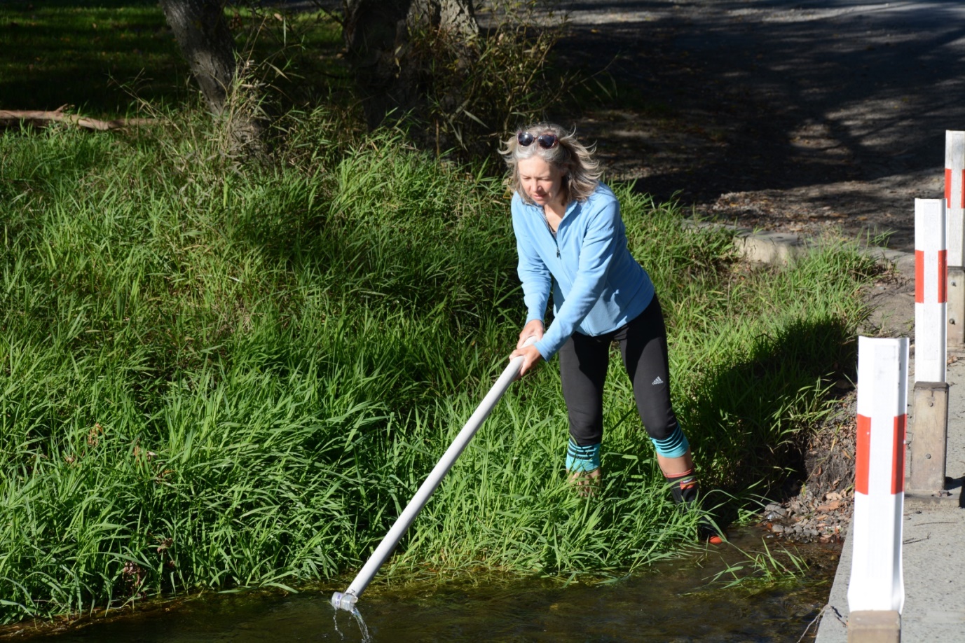
The NZFFA monthly sampling was not truly randomised but reflected the times that suited the volunteer water sampler. The photographs are evidence that the testing occurred over times of high and low flow. (Ecan flow records have been recorded on some test days).
The Selwyn River is connected to the inland unconfined Central Canterbury aquifer now polluted by industrial farming for up to 15 km from its margins. The Selwyn River might be likened to a funnel draining nitrate enriched groundwater into Te Waihora (Lake Ellesmere). In colder months when the algae in the lake stop taking up nitrate the lake water tests up to 4.5 x the NPS FM “bottom line” for New Zealand lakes making Te Waihora one of the most nitrate polluted lakes in the country.
The graph below shows the nitrate levels at Chamberlain’s Ford (red) and Coes’ Ford (Blue)
In the summer of 2020 the nitrate level at Chamberlain’s Ford peaked at 9.98 mg/L NO3-N
The low results occur when the Selwyn River is connected at the surface with its upper tributaries.
The Selwyn River differs from the Hinds River in that nitrate levels drop somewhat from Chamberlain’s to Coe’s Ford. This might be due to the river receiving adjacent groundwater that is less polluted or simply reflect the uptake of nitrate by aquatic plants between the sampling sites. By contrast nitrate levels in the Hinds River increase as this river travels to the coast.

From the LAWA NZ records of Nitrate pollution at Coe’s Ford;
Nitrogen
Total Oxidised Nitrogen
5-year median: 6.35 mg/L
State
In the worst 25% of all sites
Trend
Very Likely Degrading
Dissolved Inorganic Nitrogen
5-year median: 6.355 mg/L
State
In the worst 25% of all sites
Trend
Very Likely Degrading
Hart’s Creek
Hart’s Creek by contrast is solely sourced from groundwater.
It appears likely from limited samples of connected springs and wells that the consistently high levels of nitrate have their primary source as far away as Dunsandel and Bankside. The soils in this part of the Selwyn District are particularly shallow and porous. This is an area of large dairy farms with the Synlait dairy factory and two meat processing plants applying factory waste to land
Climate (rainfall) or season (temperatures modifying aquatic plant growth) appear to have less impact on the very high nitrate results 
Drains on Chamberlain’s Road
Several drains along Chamberlain’s Road consistently show very high nitrate levels although when the flows diminish due to local irrigation abstraction and luxuriant aquatic plant growth is occurring, nitrate levels may fluctuate by around 2.0 mg/L
It is beginning to appear that these short run drains are connected to highly polluted groundwater. My guess is that the AFFCO meat plant near Burnham and The Pines Sewage Plant servicing Rolleston and other satellite towns across the Selwyn District are influencing these results.
It is legitimate to treat wastewater by applying it to land if there is a sufficient area of land with suitable soil types available for the purpose. My results lead me to suspect this is not the case.

The Hallswell River
The relatively low nitrate levels in the Hallswell River suggest nitrate pollution from the local urban groundwater is less than from rural areas of intensive agriculture 
The LII River
The DOC/Fonterra partnership to “fix” the LII-Ararira catchment is failing to show positive change 
Water pollution is not just about nitrate
Excess nutrients such as nitrate create another problem for the lower Selwyn River in the form of toxic algae.
Waterborne pathogens from cow faeces can also pass through Canterbury’s porous aquifers resulting in the extremely dangerous O-157 strain of E.Coli being cultured from the Ashley, Selwyn and Rangitata Rivers.
While collecting water samples I was concerned to come across a gang of first generation New Zealanders commercially harvesting the prolific growth of watercress along the margins of the Selwyn River at Chamberlain’s Ford. A casual inquiry indicated this was being sold to Christchurch supermarkets.
As a onetime meat vet with a focus on public health I felt a duty to report this to MPI and the activity has ceased.
[An article about toxic algae was recently posted on the NZFFA website]


Selwyn River images

Weeds on the shingle beaches growing (hydroponically) to head height

After the May/June 2021 flood

Plants re-establishing after the flood

Chamberlain’s Ford reduced to a trickle

The site at Chamberlains Ford several months post flood

Coe’s Ford closed

Filamentous algae, high nitrate, low flow at Coe’s Ford

Ecan councillor Nicky Southward present for a water testing run

Thankfully there are a number of mainly Christchurch City councillors who recognise something must be done.
We need to elect more at the regional government elections at the end of the year
The Irwell River
The Irwell River once a great trout stream dries up most summers due to excessive irrigation abstraction

Diffuse nitrate pollution is not just a farm issue
Meat Plants and Dairy Factories are consented to apply waste water to land. AFFCO, ANZCO, Synlait, and Fonterra

ENVIRONMENTAL ISSUES IN DAIRY PROCESSING
The New Zealand Dairy Research Institute has monitored groundwater at several wastewater irrigation sites in New Zealand. Although the amount of nitrate nitrogen in groundwater under and near dairy factory irrigation sites is highly variable, at many sites the concentration is about or less than the World Health Organization recommendation of 10 g m-3. I.e. 11.3 mg/L NO3-N
III-Dairy-J-Environment-16
ANZCO’s Five Star Beef Feedlot near Ashburton
This multinational owned feedlot raises questions about animal as well as environmental welfare.

ANZCO Meat Plants
ANZCO operates meat processing plants at Seafield and at Kynvetts Road in the Selwyn District
These landlocked processing plants manage their wastewater by applying to land purchased for the purpose.
A graph of an Ecan monitoring well downslope of farmland irrigated with waste water from the ANZCO meat plant in the Selwyn District
With nitrate levels in groundwater approaching 16 mg/L NO3-N this would not appear to comply with ANZCO’s (pollution) consents?

ANZCO has appealed the proposed plan change amendment to Ecan’s Land and Water Regional Plan on the basis of:
- Its multinational ownership
- The value of its business: $NZ 1.3 billion sales
- It is an industrial and not a farming activity
- A clean, secure supply of water and the ability to effectively dispose of wastewater generated through processing and wash down activities are essential to the plant’s on-going operation
- Farming is reliant on the processing industry to turn livestock into a saleable product.
It seems foreign owned businesses like ANZCO have little interest in Canterbury’s public or ecosystem health, simply profit.
Where is Environment Canterbury?
Nitrate limits
1957 WHO Maximum Allowable Value for drinking water (New Zealand’s MAV) 11.3 mg/L NO-3N
2014 – 2019 National Policy Statement for Freshwater Management bottom line (Key Government) 6.9 mg/L NO3-N
August 2020 NPS FM ‘bottom line” 2.4 mg/L NO3-N
MfE Scientific Technical and Advisory Group (STAG) recommended “bottom line” 1.0 mg/L NO3-N
Water quality maximum for a commercial trout hatchery
1.0 mg/L NO3-N
ANZEEC (2000) bottom line to protect ecosystems was 0.44 mg/L NO3-N
The safe limit for human drinking water, (risk of bowel cancer, thyroid cancer, short term pregnancy/premature birth, neural tube defects, etc.) is unknown but likely to be very much less than the current MAV
There is a growing awareness that the WHO limit is out of date.

Dr Mike Joy’s slide summarises public and ecosystem health concerns about nitrate
Canterbury’s freshwater management is unsustainable
Environment Canterbury is failing to manage their region’s freshwater resource
Ecan’s freshwater management is founded on the Canterbury Water Management Strategy CWMS (Operative since 2010)
The CWMS is a drought response plan
Twelve years on the CWMS has achieved all its irrigation targets and not a single environmental target
It is time for a new approach yet Ecan remains committed to the CWMS and its (amended) Land and Water Regional Plan. An escalating commitment to rules derived from the politics of self-interest in the guise of “community collaboration”.
The LWRP is to be operative by the end of 2024
Compliance with the LWRP is to be achieved within the following 10 years.
Ecan is showing a singular lack of urgency and lack of comprehension in the face of a growing environmental crisis.
Dr Peter Trolove
President
NZFFA

What precious work the NZ Federation of Freshwater Anglers anbd Dr Trolove is doing. It is precious because it stands in contrast to the inertia by government, ECan, and other local organisations, all whose staff are very well paid, courtesy of the people. The Federation is voluntary effort, unpaid and performing a vital watchdog roll. Many thanks from a keen angler and ardent conservationist
I have had first hand experience with poisoned water from excessive fertilizer application.
I was in a partnership in a family cattle ranch on the flats near the Ruby River near Twin BridgesSouth western Montana USA. Maximum hay production was required for winter cattle feed, so superb “bottom land” soils were pushed to literal death with excessive fertilizers, rendering all leach & run-off waters so toxic as to be useless & deadly.After years of this round the clock/calendar routine the systems collapsed & even the soil was dead, all well water poisonous.Farmin had to be abandoned.